Jacksonville's construction activity moves fast, with over 950,000 residents now spread across the largest city by area in the contiguous United States. The sheer geographic spread, from the Trout River basin to the Intracoastal Waterway corridors, means earthwork contractors deal with dramatically different soil profiles on a single project. We see silty sands near the St. Johns River shifting to stiff clays within half a mile. That variability makes the field density test, specifically the sand cone method under ASTM D1556, a non-negotiable checkpoint before placing foundations or pavement. When a 40-acre distribution center goes up near Cecil Field, the geotechnical engineer isn't guessing at compaction; they're pulling sand cone data every 2,500 square feet. The combination of high groundwater, frequent afternoon storms, and layered coastal sediments demands verification that goes beyond a nuclear gauge reading. Our team runs sand cone tests alongside Atterberg limits when fill material classification is ambiguous and the moisture-density relationship needs recalibration mid-project.
In Jacksonville's coastal sediments, a properly executed sand cone test catches density deficits that a nuclear gauge can miss when organic layers scatter the reading.
How we work
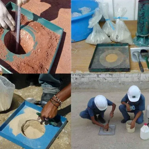
Florida Building Code Section 1804 references compaction criteria that tie directly to the sand cone method for determining in-place density of soils that are not highly plastic. Jacksonville's typical road subgrade, often an A-3 or A-2-4 material under AASHTO classification, works well with the sand cone because the excavation remains stable and the Ottawa sand flows cleanly into the test hole. The procedure requires careful hand excavation to a depth of 4 to 6 inches, avoiding disturbance of the surrounding material, which matters enormously in partially saturated sands that can collapse if jarred. We collect a representative sample for moisture content determination, then calculate the dry density against the laboratory Proctor curve. What makes Jacksonville conditions distinct is the frequency of shell fragments and organic lenses in near-surface soils east of US-1. Those inclusions can artificially inflate volume measurements if the technician doesn't trim the hole walls meticulously. The method delivers reliable results for granular soils with less than 10% retained on the 3/4-inch sieve, which covers most of the local borrow material sourced from ridge deposits west of I-295.
Local geotechnical context
Much of Jacksonville sits on the Atlantic Coastal Plain, with surface geology dominated by Pleistocene terrace deposits and Holocene marsh sediments. The natural soil profile east of the Cody Scarp includes loose, saturated sands interbedded with soft organic silts that rarely exceed 85% relative density without mechanical improvement. Compaction specifications calling for 98% modified Proctor are achievable in the cleaner sands of the western uplands, but near the river and its tributaries, contractors hit material that pumps under vibratory rollers. We've measured sand cone densities in the Arlington area where three lifts of select fill still tested below 95% because the underlying organic layer was deforming elastically under compaction energy. Jacksonville's summer rainfall pattern adds another dimension: a 2 PM thunderstorm can saturate an open excavation in 20 minutes, skewing the moisture content and forcing rework. The sand cone test becomes an active quality control tool rather than a passive check, guiding the superintendent on whether to scarify, dry back, or replace before the next lift goes down.
Questions and answers
What does a field density test with the sand cone method cost in Jacksonville?
For most commercial and residential projects in the Jacksonville area, a single ASTM D1556 sand cone test runs between US$100 and US$170 per point, depending on site access, travel distance, and whether the technician needs to collect a companion Proctor sample. Projects with more than 20 test points typically qualify for reduced per-unit pricing when scheduled as a continuous quality control program.
How long does a sand cone density test take to complete on site?
A single test point takes roughly 15 to 20 minutes from excavation to backfill, including moisture content measurement. The technician excavates the test hole by hand, collects all excavated material in a sealed container, pours the calibrated Ottawa sand through the cone apparatus, and calculates the in-place density on the spot. The process moves faster in clean sands typical of Jacksonville's western ridge areas and slightly slower in the shell-laden soils near the Intracoastal.
When is the sand cone method preferred over a nuclear gauge in Jacksonville?
The sand cone becomes the preferred method when testing soils with high organic content, shell fragments, or significant mica, all common in Duval County's coastal deposits. Nuclear gauges can produce skewed readings in these materials because the hydrogen content of organic matter affects the neutron moderation measurement. The sand cone also serves as the referee method when nuclear gauge readings are disputed, since it provides a direct measurement of volume and mass with no calibration assumptions about soil chemistry.
How many sand cone tests does Jacksonville building code require for a commercial slab?
The Florida Building Code references the geotechnical engineer's recommendation, but standard practice for a commercial slab-on-grade in Jacksonville follows a minimum frequency of one test per 2,500 square feet of building footprint, with additional tests in utility trench backfill zones. For FDOT roadway projects, Specification 125-4.1 defines frequency based on lift thickness and subgrade material type, typically resulting in a test every 150 linear feet per lift.